- Home
- About Us
- Solutions
-

- Solutions by Industry
- Overview
-
- Microsoft Dynamics Business Solution
- Overview
- Our Offerings
- Product Capabilities
- Industry Specific
-
- Services
- Clients
- Contact Us

In Geo-spatial services and solutions we encompass a wide range of offerings that leverage geographic information systems (GIS), remote sensing technologies, global positioning systems (GPS) and other spatial data tools to address various challenges and opportunities across industries. These services and solutions involve the collection, analysis, visualization and interpretation of spatial data to derive actionable insights and make informed decisions. Here are some key components and examples of geo-spatial services and solutions:
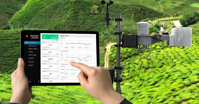
Geographic Information Systems (GIS):
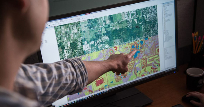
With the GIS foundational technology we facilitate the users to capture, store, manipulate, analyse and present spatial and geographic data. GIS software enables organizations to create maps, perform spatial analysis and manage geographic information efficiently.
Remote Sensing:
We incorporate Remote sensing in the systems. It comprises of capturing information about the Earth's surface from a distance, typically using satellites, aircraft or drones. Remote sensing data, such as satellite imagery and aerial photographs aids various applications which include land cover mapping, environmental monitoring and disaster assessment.

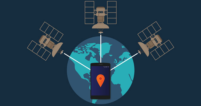
Global Positioning Systems (GPS):
With the help of GPS technology we enable the precise determination of location and navigation using signals from satellites. The GPS data can be integrated into GIS platforms for geo tagging of assets, track movement and conduct field surveys with high accuracy.
Spatial Analysis:
We incorporate Spatial analysis in our solutions which comprise of examining geographic patterns, relationships and trends within the spatial data. This facilitates proximity analysis, spatial interpolation, terrain modelling and network analysis to derive meaningful insights from spatial datasets.
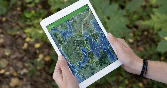
Mapping Services:
We provide accurate Mapping services which involve creating, customizing and updating digital maps for specific purposes or applications. This can include thematic mapping, interactive web mapping and mobile mapping solutions tailored to meet the needs of businesses, governments and organizations.
Environmental Monitoring and Management:
The Geo-spatial solutions provided by us find utility for monitoring and managing environmental resources such as water quality, air pollution and habitat conservation. These solutions help organizations to track changes in the environment, assess environmental risks and develop strategies for sustainable resource management.
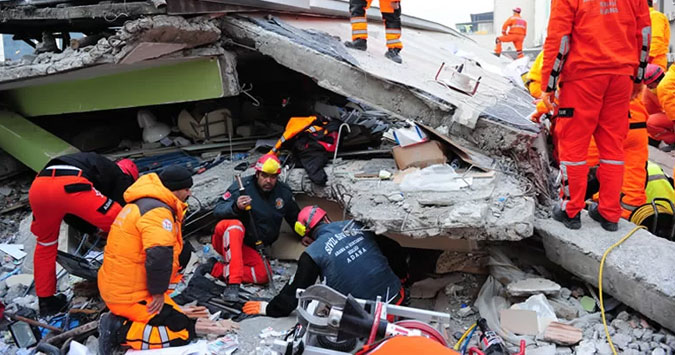
Disaster Management and Emergency Response:
With the help of the Geo-spatial solutions we provide valuable insights in the prediction and awareness about the Disaster prone areas or the areas that are likely to be affected by a natural calamity. Our Geo Spatially equipped systems play a critical role in disaster preparedness, response and recovery efforts. By leveraging multiple technologies we provide the mapping of vulnerable areas for assessing the risk factors and coordinating the emergency resources, organizations to mitigate the impact of natural disasters and save lives.
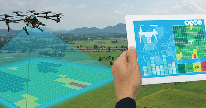
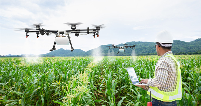
Precision Agriculture:
We provide precision agriculture solutions leveraging the GPS, GIS and remote sensing data to enable farmers to make data-driven decisions and maximize productivity. The Geo-spatial technologies play a vital role in agriculture to optimize crop management practices, monitor soil conditions and improve yield forecasting.
Infrastructure Planning and Asset Management:
Our Geo-spatial services support infrastructure planning and asset management by providing accurate geospatial data for infrastructure related projects such as : Roads, utilities and buildings. These solutions help organizations optimize infrastructure investments, plan for maintenance and ensure asset reliability.

What we offer:
We specialize in web, mobile and cloud-based Geo Spatial services & solutions by creating robust and user-friendly applications that solve complex problems. We create sophisticated mapping applications with advanced geospatial analysis capabilities and deliver tailored services across sectors like urban planning, environmental management and transportation. We hold expertise in satellite and aerial imagery analysis which enables us to provide with valuable insights for environmental monitoring, land use classification and disaster assessment. Our accurate and detailed solutions aid in informed decision-making, resource management and sustainable development. We offer comprehensive solutions for businesses and government agencies to leverage location-based data. Our services encompass object detection, recognition, segmentation, and enhancement across diverse applications ranging from medical imaging to autonomous vehicles. We offer comprehensive solutions for managing, analyzing and visualizing geospatial data.

GIS Based Turnkey Solutions:
We provide GIS-based turnkey solutions that facilitate end-to-end solutions covering all aspects of a project or activity. This ranges from planning and collection of data to analysis, implementation and maintenance. These solutions are tailored to meet the unique requirements and challenges of specific applications while ensuring effective results. These solutions encompass complete packages designed to address specific needs or projects across various domains such as urban planning, rural development, mining operations, forest management and geo-tagging. We develop the software applications which are equipped for handling spatial analysis, map design, geo processing and visualization. Our interface provides the users to perform complex geospatial tasks like overlay analysis, buffering, network analysis, spatial interpolation and 3D visualization.
We provide seamless services in the following:
Urban Planning:
For urban planning we provide the tools and services which include land use mapping, infrastructure development, transportation planning and spatial analysis to support sustainable urban growth and development.
In urban planning sector, we incorporate:

(I). Map Digitization:
This involves converting of the analog spatial data into maps. We also convert surveys and aerial photographs into digital formats which can be stored, analyzed and shared using computers and Geo Spatial software. These functionalities enable easier access, manipulation and integration of spatial data which leads to improved efficiency and accuracy in mapping and analysis. We integrate digitized spatial data with other digital datasets namely: Satellite imagery, GPS data and demographic information to create comprehensive GIS databases for analysis and visualization.

(II). Geo-Tagging:
Our Geo-tagging solutions enable the identification, tracking and management of assets (resources or infrastructure). The geographic co-ordinates and spatial data is utilised for performing these tasks. We also facilitate the tagging of physical assets such as utility poles, infrastructure assets (or natural resources) with location-based information for inventory.

(III). GNSS:
We incorporate Global Navigation Satellite Systems (GNSS) technology in our solutions to ensure precision and facilitate effective planning. GNSS utilizes a network of satellites to provide real-time positioning and timing of data which yields accurate geospatial referencing and mapping. This multi-dimensional approach enables stakeholders to pinpoint locations with high precision. This accuracy is crucial for various applications like surveys, infrastructure development, environmental monitoring and disaster management. GNSS-enabled digital maps facilitate efficient navigation and resource allocation in the field while reducing the costs.

Rural Development:
Our comprehensive solutions for rural development encompass a variety of components aimed at facilitating sustainable growth and improving livelihood in rural areas.
These components include:
(I). Land Management:
We provide efficient solutions that promote strategic land use by developing systems that simplify land consolidation, land redistribution and automate land tenure systems to optimize agricultural productivity and ensure access to land resources.

(II). Agricultural Planning:
We develop systems which enhance agricultural productivity, food security and rural incomes. With the help of Geo Spatial technology we create crop diversification plans and irrigation systems along with many more customer specific requirements in order to infuse sustainable farming practices along with the pre-existing ones.
(III). Natural Resource monitoring for rural development
We ensure sustainable resource management by monitoring the natural resources such as water sources, forests and grazing lands. This also promotes conservation of resources and prevent environmental degradation.

(IV). Socio-economic Analysis
We conduct socio-economic assessments to understand the needs, challenges and opportunities within rural communities. This analysis helps in designing targeted interventions, promoting entrepreneurship, improving access to education and healthcare.
Our rural development solutions aim to empower rural communities, bridge the urban-rural divide and promote inclusive and sustainable development.

(V). Mining Operations:
Our solutions for the mining industry offers varied tools for mineral exploration, site selection, environmental impact assessment, mine planning and monitoring to optimize resource extraction while ensuring environmental compliance.

(VI). Forest Management:
We incorporate mapping technologies forest resources, monitoring biodiversity, assessing forest health and implementing conservation measures. We utilize Geographic Information Systems (GIS) to gather, analyse and visualize spatial data related to forests, including forest cover, species distribution, soil types and more.
Components Included:
Software:
- The GIS-based application software provides tools and functionalities for creating, editing, analysing and visualizing spatial data within a geographic information system (GIS) environment.
- GIS software forms the core component of GIS-based turnkey solutions which provides tools for data management, spatial analysis, mapping and visualization.
Hardware:
- Turnkey solutions may include hardware components such as GPS receivers, Drones, surveying equipment, mobile devices and servers to facilitate data collection, processing and analysis.
Data Collection Tools:
- These solutions often include tools and technologies for collecting spatial data such as satellite imagery, aerial surveys, GPS surveys, LiDAR data and field data collection apps.
Training:
- We provide training programs that are designed to educate users on how to use the software, hardware and data collection tools effectively.
Ongoing Support:
- We aim at customer satisfaction by offering ongoing technical support, maintenance and updates to ensure the continued functionality and efficiency of the system.
Advanced Technologies incorporated:
We deploy AI & ML, Map digitization and GIS-based application software systems which are critical for addressing complex spatial challenges and leveraging the full potential of geospatial data. These technologies enable organizations to automate repetitive tasks.
Surveys:
We specialize in delivering cutting-edge geospatial solutions and systems designed to seamlessly integrate with varied survey methods to transform raw data into actionable insights that drive informed decision-making. We empower organizations to unlock their maximum potential with the help of spatial solutions.

Drone and Rover Surveying:
We facilitate deeper land studies with the help of Drones and Rovers (aerial or ground-based vehicles equipped with sensors, cameras and other instruments for data collection) that capture high-resolution images and collect data of large areas efficiently.
Drones are particularly useful for aerial surveying as they provide flexible and cost-effective solutions for mapping terrain, monitoring land use changes and assessing environmental conditions.
Rovers are employed for ground-based surveying tasks, navigating rugged terrain and inaccessible areas to gather data with precision.
Aerial View Surveying:
Aerial view surveys involve capturing images or data from an elevated perspective which typically uses aircraft or drones. We deploy this technique to provide a broad perspective of the landscape which allows comprehensive mapping and analysis of large areas. The aerial imagery obtained from these surveys can be used for various purposes which includes land use planning, infrastructure development, environmental monitoring and disaster assessment. We incorporate advanced sensors and cameras mounted on aircraft or drones that capture high-resolution images and collect data on terrain elevation, vegetation cover, land use patterns and other relevant parameters.

Physical Surveying:
Physical surveying encompasses traditional ground-based data collection methods using surveying equipment and tools. This includes techniques such as using GPS devices and levelling instruments to measure and record precise location information. We conduct physical surveys on-site by surveyors or field technicians who collect data points by traversing the terrain and taking measurements at designated locations, these surveys are essential for obtaining accurate spatial data for engineering projects, construction activities, property boundary delineation and cadastral mapping.

Importance and Applications:
- Drone and rover surveying provide aerial view surveying and physical surveying which play vital roles in various fields that include civil engineering, land management, environmental science, agriculture and urban planning.
- These techniques help to monitor environmental changes and facilitate disaster response and recovery efforts.
- These surveys enable the stakeholders to make informed choices and optimize resource allocation.
LiDAR Survey:
We incorporate LiDAR (Light Detection and Ranging) Surveys in our Geo-spatial approaches that aids in Geo-referencing, Topographical Mapping and Image Processing which constitutes as integral components of modern geospatial data collection and analysis methods. It is a remote sensing technology that uses laser pulses to measure distances to the Earth's surface.
- LiDAR sensors emit laser beams towards the ground and the time it takes for the laser pulses to return is used to calculate the distance to objects on the Earth's surface.
- These surveys can create highly detailed 3D maps of terrain, vegetation, buildings and other features by collecting millions of these distance measurements.
- The data collected by LiDAR surveys is utilized in various applications which include forestry, urban planning, flood risk assessment, infrastructure planning and natural resource management.

Technologies incorporated:
Geo-referencing:
The Geo-referencing involves aligning spatial data such as LiDAR point clouds or aerial imagery with real-world co-ordinates that ensure accuracy and compatibility with other datasets. This process typically involves referencing the spatial data with the known geographic co-ordinates which uses ground control points, GPS measurements and satellite imagery. Geo-referencing enables spatial data to be accurately integrated into Geographic Information Systems (GIS) and is used for mapping, analysis and decision-making.
Topographical Mapping
We incorporate Topographical mapping which utilizes the elevation of data derived from LiDAR surveys to create detailed maps showing the shape and features of the Earth's surface. The LiDAR-derived elevation models can accurately represent terrain features such as hills, valleys, ridges and drainage patterns. These maps are essential for various applications, including land use planning, engineering design, slope stability analysis and natural hazard assessment.
Image Processing:
We use the Image processing techniques to enhance and analyze aerial or satellite images for various purposes. This may involve applying filters, algorithms and statistical methods to improve image quality, remove noise and for extraction of relevant information.
Importance and Applications:
- LiDAR surveying comprises of geo-referencing, topographical mapping and image processing which play a crucial role for a wide range of applications across multiple industries.
- These processes provide valuable spatial data and insights that support decision-making in fields such as urban planning, natural resource management, environmental monitoring, infrastructure development and disaster management.
- By leveraging LiDAR technology and image processing techniques, organizations can accurately map and analyze the Earth's surface, identify spatial patterns and trends thereby facilitating informed decisions to address complex challenges and opportunities.
- The Image processing performed by LiDAR is used in applications such as land cover classification, change detection, object detection and environmental monitoring.